What was the first picture of Earth taken from space?
The first photograph of Earth taken from space was captured during a suborbital flight by a V-2 rocket on October 24, 1946. The rocket was launched from the White Sands Missile Range in New Mexico, USA, as part of a series of tests conducted by the U.S. Army. The V-2 rocket, developed by German engineer Wernher von Braun during World War II, was repurposed for scientific research after the war.
The camera attached to the V-2 rocket reached an altitude of 65 miles (105 kilometers) and took the first black-and-white photograph of Earth from space. The image, known as the "V-2 Photo," shows a curved Earth against the backdrop of space. It was a historic milestone in space photography and marked the beginning of capturing images of our planet from beyond its atmosphere.
It's important to note that this photograph was taken during a suborbital flight, meaning the rocket did not achieve orbit around the Earth. The first images of Earth from a satellite in orbit were captured later, with the launch of the satellite Explorer 6 in 1959, which transmitted the first crude television pictures of Earth from orbit.
The V-2 Photo and subsequent images from space played a significant role in shaping our understanding of Earth's atmosphere, weather patterns, and the fragility of our planet when viewed from the vastness of space.
Who took the first photograph of Earth from space?
The first photograph of Earth from space was taken on October 24, 1946, by a 35mm motion picture camera mounted on a V-2 rocket launched from White Sands Missile Range in New Mexico. The camera was part of a scientific payload that was designed to take measurements of the Earth's atmosphere.
- What was the significance of the first picture of Earth from space?
The first photograph of Earth from space was a groundbreaking achievement that had a profound impact on our understanding of our place in the universe. It was the first time that humans had ever seen their planet from a global perspective, and it helped to foster a sense of global interconnectedness and shared humanity.
How has the technology for capturing images of Earth from space evolved since the first photograph?
The technology for capturing images of Earth from space has evolved dramatically since the first photograph was taken in 1946. Today, we have satellites that can orbit the Earth and take high-resolution images of its surface, as well as spacecraft that can travel to other planets and take pictures of them from space.
Here is a brief overview of the evolution of Earth imaging technology:
1946: The first photograph of Earth from space was taken using a 35mm motion picture camera mounted on a V-2 rocket.
1959: Explorer 6, the first American satellite to orbit the Earth, took pictures of the planet's cloud cover.
1960: TIROS 1, the first weather satellite, transmitted images of Earth back to Earth.
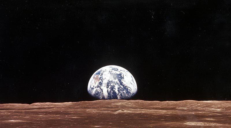
1966: Lunar Orbiter 1, a NASA spacecraft orbiting the Moon, took detailed pictures of Earth.
1972: Landsat 1, the first Earth-observing satellite to be launched by the United States, began transmitting high-resolution images of the planet's surface.
1997: The European Space Agency (ESA) launched the first satellite in the Envisat series, which provided a comprehensive view of the Earth's environment.
2000: NASA launched Terra, the first satellite in the Earth Observing System (EOS) series, which is designed to provide long-term observations of the Earth's climate and environment.
2015: The Copernicus Sentinel-2 mission, a joint ESA and European Commission initiative, began providing high-resolution images of Earth for a variety of applications, including agriculture, forestry, and disaster monitoring.
Today, we have a vast array of satellites and spacecraft that are constantly capturing images of Earth from space. These images are used for a variety of purposes, including weather forecasting, environmental monitoring, and resource management. They also provide us with a stunning and ever-changing view of our home planet.