Calculating Distance Between Coordinates
A comprehensive guide to understanding and calculating the distance between two points on Earth. This interactive application breaks down the core concepts, compares different methods, and provides a hands-on tool for your own calculations.
Interactive Distance Calculator
Enter the latitude and longitude for two points to calculate the straight-line (geodesic) distance between them using the Haversine formula.
Point 1
Point 2
Core Concepts Explained
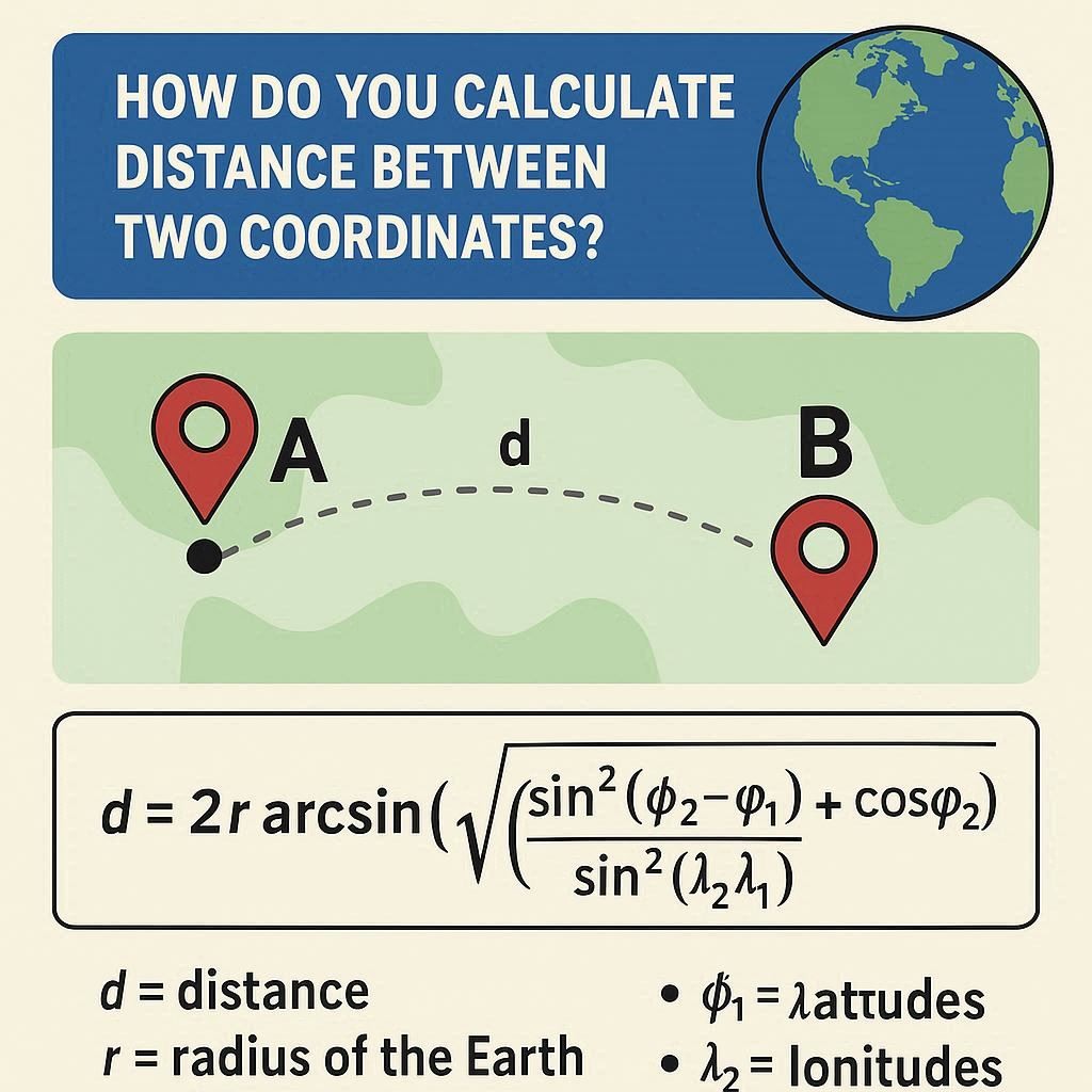
To accurately calculate distance, it's important to understand the underlying principles. This section breaks down the key concepts and formulas used in geolocation.
What is the Haversine formula?
The Haversine formula is a vital equation in navigation, used to calculate the great-circle distance between two points on a sphere given their longitudes and latitudes. "Great-circle distance" is the shortest distance between two points on the surface of a sphere, also known as the "as the crow flies" distance.
It's especially important for long-distance calculations because it accounts for the Earth's curvature, which simpler formulas like Euclidean distance do not. It treats the Earth as a perfect sphere, which is accurate enough for most applications.
The Formula:
a = sin²(Δφ/2) + cos φ₁ ⋅ cos φ₂ ⋅ sin²(Δλ/2)
c = 2 ⋅ atan2(√a, √(1−a))
d = R ⋅ c
Where: φ is latitude, λ is longitude, R is earth’s radius (mean radius = 6,371km); Δ represents the difference.
Can latitude and longitude be used on a map?
Absolutely. Latitude and longitude form a grid system that allows us to specify any location on Earth. When you have the coordinates of two points, you can use them to calculate the distance between them.
- Latitude (Parallels): These lines run east-west but measure distance north or south of the Equator (0°). They are parallel to each other.
- Longitude (Meridians): These lines run north-south from pole to pole and measure distance east or west of the Prime Meridian (0°). They converge at the poles.
While you can plot these points on a flat map, calculating the distance requires a formula like Haversine to account for the map's distortion of the spherical Earth. A straight line on a flat map is not the shortest path for a long journey.
Methods Compared
The method you choose depends on your needs. Are you calculating a flight path or a road trip? Understanding the difference is key to getting a useful result.
Euclidean vs. Geodesic Distance
The core difference lies in the surface being measured: a flat plane versus a curved sphere.
Euclidean
Calculates the straight-line distance in a flat, 2D plane. It's simple and fast but becomes highly inaccurate over long distances on Earth because it ignores curvature.
Geodesic
Calculates the shortest path on a curved surface (a great circle). This is the method used by the Haversine formula and is accurate for global distances.
Driving vs. Straight-Line Distance
This compares the theoretical shortest path with the practical route you'd actually travel.
Straight-Line (Geodesic)
This is the "as the crow flies" distance calculated by the Haversine formula. It's useful for aviation, shipping, and understanding the direct distance between two locations.
Driving Distance
This is the distance along actual roads. It's almost always longer than the straight-line distance due to turns, terrain, and obstacles. Calculating this requires complex routing algorithms and mapping data from services like Google Maps or OpenStreetMap.
Online Tools & Apps
For quick calculations or complex routing, these online tools and APIs are excellent resources. They handle the complex math and provide rich mapping features.
Google Maps
The standard for driving, walking, and transit directions. Right-click on the map and select "Measure distance" for a simple straight-line tool.
Movable Type Scripts
A popular and straightforward web-based tool for calculating great-circle distance using various formulas, including Haversine.
National Geodetic Survey
Provides high-precision tools for geodesic calculations, taking into account the Earth's true ellipsoidal shape for maximum accuracy.